Read UPDATES
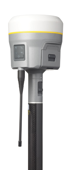
As some of you already know, Trimble launched the new Trimble R10 system two days ago(Oct. 9, 2012) in HANNOVER, Germany at INTERGEO 2012, the so called “world’s largest conference on geodesy, geoinformatics and land management“, so I’ll write my personal impressions on the new Trimble R10.
You can read the original news release by trimble here, but I’ll make a summary for you about what’s new about this new system.
Of course Trimble knows how to market their products, so they unveiled lots of “new excitement features”. As I see it there are 2 or maybe 3 things that are really new features and not just minor improvements of the now-old Trimble R8 system.
Let’s get started with the coolest(or hotter, whatever) new feature, Trimble xFill. It sounds like some sort of simple stakeout feature, but it’s not. It’s a system that allows you to get some extra signals by satellite or by cellular. During the last decade GNSS systems improved that much, that an extra-signal might not seem so impressive. We already have GLONASS, Galileo, Compass, SBAS and lots of other systems, so at first xFill didn’t impressed me too much either.
The really cool thing about xFill is that it wasn’t created to improve the overall accuracy, but to provide a reasonable accuracy in some harsh conditions. In my opinion, this is genius of Trimble that they didn’t push it for an extra mm accuracy, just for the sake of it, maybe they learned from Apple’s failure with their extra 1cm iPhone5.
So, what does it do?
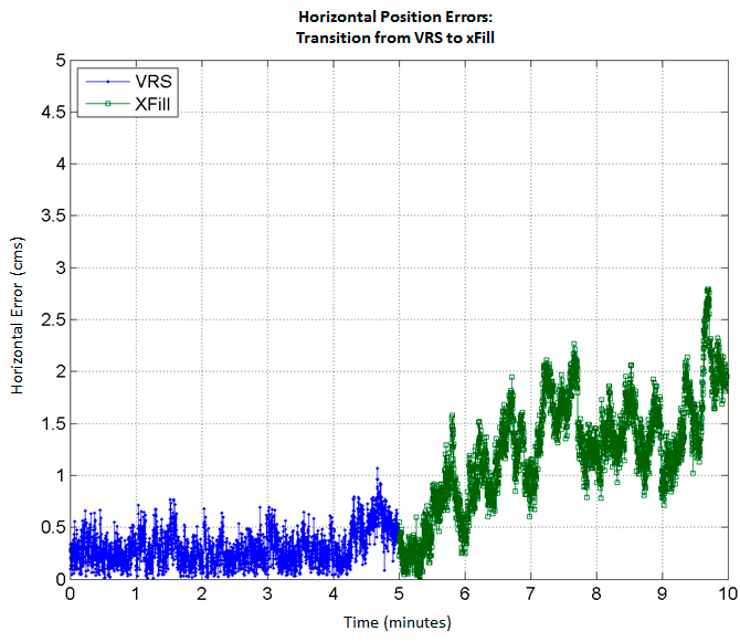
Let’s suppose you’re doing some RTK VRS surveying in some remote area(for most of the surveyors this is pretty standard) and the cellular coverage is poor and it drops every few minutes which also disconnects you from the VRS server. In this kind of conditions you must wait and hope you’ll get cellular signal again. Now with the xFill you don’t have to wait anymore, if you get disconnected from your main source of RTK corrections(VRS, single-base or whatever) you can continue to work for some extra-minutes(3 to 5 minutes) at a reasonable accuracy. Of course the accuracy will drop a little during these cellular signal(or radio) shortage, but it will still be surveying level. Here’s a graphic that shows how accuracy drops when using xFill during cellular signal shortage.
I haven’t actually did the test myself. This graph is taken from this white-paper from trimble.
How does it work?
Data from a permanent GNSS station network is sent to some servers, processed, then the corrections are sent to Trimble’s satellites which send the corrections back to your Trimble R10. You can also get these corrections by internet, instead of getting them through Trimble’s satellites, but if you don’t have enough bars on your cell to connect to your main RTK corrections source, then you won’t be able to use xFill either. Here’s a flowchart taken from the same white paper.
What’s the catch?
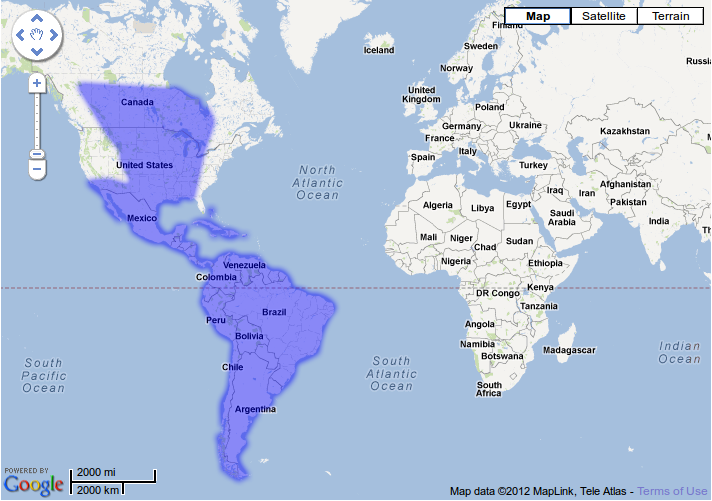
UPDATE2: There’s no catch anymore, here is the new Trimble xFill coverage.

If you live anywhere in the Americas, there’s no catch, it just works. If you don’t live in the Americas, then you should check the underneath map or the interactive map from trimble for the RTX satellite service, but take my word for it, you’re out of luck.

The only option left for those of you who, like me, don’t live in the Americas is to use some sort of internet connection to receive xFill corrections – the gray crossed option in the previous diagram – but as I stated before, if somehow you get an internet connection you’ll probably connect to your primary RTK corrections source.
The bottom line is that for European market, this system is only useful for those who rely on radio based RTK systems, who, for some reason, don’t control the GNSS base which sends the corrections through radio. I find this situation to be extremely rare, in Romania at least, so I’ll check this feature out again when Trimble will have satellite coverage over Europe too. Launching this pretty cool feature at INTERGEO in Europe(9-11 October), with Trimble Dimensions 2012 on its way to Las Vegas(5-7 November) seems odd and it feels frustrating and somehow annoying. It’s like they just wanted to brag on themselves about how great America and Americans are.
Going on to the next R10 cool feature – the eBubble
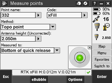
The eBubble is nothing else than a digital bubble displayed on the controller. So it’s basically what is already known as a G-Sensor in the smart-phone slang. It’s nothing new to the world, smartphones have it, total stations have it, the GNSS systems were the only one left out with a traditional bubble. The eBubble was bound to happen a long time ago. I don’t actually understand how nobody thought of using a G-Sensor in a GNSS system. Leica, Topcon, and others, WAKE UP!
Side note: If any of my teachers is reading this, hear me out. Anyone is calling it a bubble, because it’s a bubble. Of course there are a few who use fancy terms like spherical level and fine-level for bubbles, but I’ll continue to use the word bulă(exact translation of the word bubble in Romanian)
What’s so great about an eBubble?
1. You don’t have to look in two places before storing a point. You have the bubble right on your screen.
2. The actual tilt of the pole is recorded. Combine this with the height of the pole and you can use this to process your data even more. The new Trimble Business Center 2.8 supports Trimble R10, so I suppose it also support tilt data.
Other new features
Of course, the new Trimble R10 is smarter, faster, lighter and even better-looking than any of its predecessors or any other existing similar product on Earth. It’s a new product, how else could it be?
I got most of the information to write this post from the following sources:
- Trimble News Release http://www.trimble.com/news/release.aspx?id=100912a
- White Paper – Trimble xFill RTK – English http://www.trimble.com/survey_wp.asp?Nav=Collection-92139
- Trimble Correction Services – Coverage Maps http://www.trimble.com/positioning-services/interactive-map/interactive-map.aspx
- Trimble R10 Datasheet http://www.trimble.com/globalTRLTAB.asp?nav=Collection-90566
When I’ll get a price for the new Trimble R10, I’ll update this post.
UPDATE1: My dealer told me that the new Trimble R10 is about 2000E more expansive than Trimble R8, which means about 20 000E. Compared to R8, R10 has a fair price. Compared to other brands, any Trimble product seems a little bit too expensive. I suppose they charge us with some kind of jewelry tax.
UPDATE3:Regarding Trimble R10’s price, the actual price is just a little bit higher than 20.000E. The difference between R8 and R10 is really the xFill features, if you have strong internet connection, or you always roll with a base receiver, than R10 or R8 will satisfy you just as well. If you really need to buy a new receiver go for R10, because R8 prices didn’t go down, and they won’t.
Have something to say? Write a comment!


